Convergent Plate Boundaries and Subduction
At convergent plate boundaries, two plates, at least one of which is oceanic, move toward one another. But rather than butting each other like angry rams, one oceanic plate bends and sinks down into the asthenosphere beneath the other plate. Geologists refer to the sinking process as subduction, so convergent boundaries are also known as subduction zones. Because subduction at a convergent boundary consumes old ocean lithosphere and thus ‘‘consumes’’ oceanic basins, geologists also refer to convergent boundaries as consuming boundaries, and because they are delineated by deep-ocean trenches, they are sometimes simply called trenches. The amount of oceanic plate consumption worldwide, averaged over time, equals the amount of sea-floor spreading worldwide, so the surface area of the Earth remains constant through time.
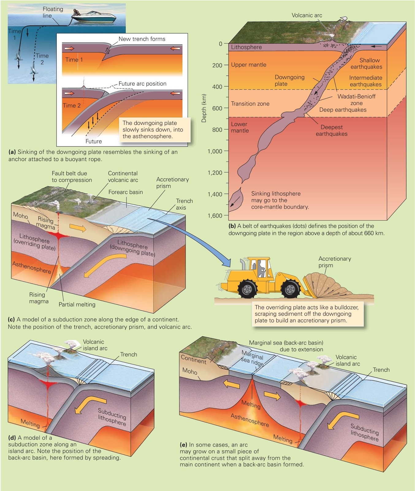 |
| During the process of subduction, oceanic lithosphere sinks back into the deeper mantle. |
Subduction occurs for a simple reason: oceanic lithosphere, once it has aged at least 10 million years, is denser than the underlying asthenosphere and thus can sink through the asthenosphere if given an opportunity. Where it lies flat on the surface of the asthenosphere, oceanic lithosphere can’t sink. However, once the end of the convergent plate bends down and slips into the mantle, it continues downward like an anchor falling to the bottom of a lake (figure above a). As the lithosphere sinks, asthenosphere flows out of its way, just as water flows out of the way of a sinking anchor. But unlike water, the asthenosphere can flow only very slowly, so oceanic lithosphere can sink only very slowly, at a rate of less than about 15 cm per year. To visualize the difference, imagine how much faster a coin can sink through water than it can through honey.
Note that the “downgoing plate,” the plate that has been subducted, must be composed of oceanic lithosphere. The overriding plate, which does not sink, can consist of either oceanic or continental lithosphere. Continental crust cannot be subducted because it is too buoyant; the low-density rocks of continental crust act like a life preserver keeping the continent afloat. If continental crust moves into a convergent margin, subduction eventually stops. Because of subduction, all ocean floor on the planet is less than about 200 million years old. Because continental crust cannot subduct, some continental crust has persisted at the surface of the Earth for over 3.8 billion years.
Earthquakes and the Fate of Subducted Plates
At convergent plate boundaries, the downgoing plate grinds along the base of the overriding plate, a process that generates large earthquakes. These earthquakes occur fairly close to the Earth’s surface, so some of them cause massive destruction in coastal cities. But earthquakes also happen in downgoing plates at greater depths. In fact, geologists have detected earthquakes within downgoing plates to a depth of 660 km. The band of earthquakes in a downgoing plate is called a WadatiBenioff zone, after its two discoverers (figure above b).
At depths greater than 660 km, conditions leading to earthquakes in subducted lithosphere evidently do not occur. Recent observations, however, indicate that some downgoing plates do continue to sink below a depth of 660 km they just do so without generating earthquakes. In fact, the lower mantle may be a graveyard for old subducted plates.
Geologic Features of a Convergent Boundary
To become familiar with the various geologic features that occur along a convergent plate boundary, let’s look at an example, the boundary between the western coast of the South American Plate and the eastern edge of the Nazca Plate (a portion of the Pacific Ocean floor). A deep-ocean trench, the Peru-Chile Trench, delineates this boundary (figure above b). Such trenches form where the plate bends as it starts to sink into the asthenosphere.
In the Peru-Chile Trench, as the downgoing plate slides under the overriding plate, sediment (clay and plankton) that had settled on the surface of the downgoing plate, as well as sand that fell into the trench from the shores of South America, gets scraped up and incorporated in a wedge-shaped mass known as an accretionary prism (figure above c). An accretionary prism forms in basically the same way as a pile of snow or sand in front of a plow, and like snow, the sediment tends to be squashed and contorted.
A chain of volcanoes known as a volcanic arc d evelops behind the accretionary prism. The magma that feeds these volcanoes forms just above the surface of the downgoing plate where the plate reaches a depth of about 150 km below the Earth’s surface. If the volcanic arc forms where an oceanic plate subducts beneath continental lithosphere, the resulting chain of volcanoes grows on the continent and forms a continental volcanic arc. (In some cases, the plates squeeze together across a continental arc, causing a belt of faults to form behind the arc.) If, however, the volcanic arc grows where one oceanic plate subducts beneath another oceanic plate, the resulting volcanoes form a chain of islands known as a volcanic island arc (figure above d). A back-arc basin exists either where subduction happens to begin offshore, trapping ocean lithosphere behind the arc, or where stretching of the lithosphere behind the arc leads to the formation of a small spreading ridge behind the arc (figure above e).
Credits: Stephen Marshak (Essentials of Geology)